That many people are affected doesn't in itself make a case for the relationship of the fire to changes in the global climate. All it marks is the sense of the tragedy of those affected, hence why the fire in 74-75 whilst clearly bigger in scale isn't something that is marked in the Australian memory as much as it was in such a remote place as to not affect as many people compared to other Australian fires in terms of people dying, damaging property and disrupting life.
Although such damage did occur.
https://www.nzherald.co.nz/world/news/article.cfm?c_id=2&objectid=12298682But the most destructive event, which happened in 1974 and burned 117 million hectares, does not have a name because most of the land was in central Australia and so it did not impact many communities. "The 1974/75 fires had almost no impact and much of the damage was found by satellite after the fact," Prof Pyne told news.com.au.
...
AUSTRALIA, 1974
Death toll: 3 people in NSW
Damage: About 117 million hectares
During the summer between 1974 and 1975, Australia experienced its worst bushfire season in 30 years.
About 15 per cent of Australia's physical land mass sustained extensive fire damage.
New South Wales was badly affected with widespread damage to infrastructure, including communications, roads, railways and property fencing. Farmers lost crops and livestock. The areas affected included those in the western part of the state in Cobar Shire, Balranald, Glendale and regions around the Lower Hunter. The overall damage cost was estimated at approximately A$5 million.
But instead of saying which fire swings a bigger dick, the qualitative differences need to not only be noted factually but explained in their significance.
So we see the example of the 74-75 fires being the result of vegetation growth, a lot more grass.
What does this mean in contrast to the recent and ongoing fires that were a result of dryness and severe drought conditions amidst one of the worst heatwaves across Australia? What is the relationship of one to the other? Because they seem to be two different fires and one is neither a golden bullet against or for climate change.
https://www.theguardian.com/australia-news/2019/nov/22/australia-bushfires-factcheck-are-this-years-fires-unprecedentedBut scientists says fire conditions today are fundamentally different, and fundamentally worse in many ways, when compared with some of the fires experienced in the past.
The centre’s director, Ross Bradstock, says the 1974 fires burned through largely remote country mostly in the state’s far west, devouring green, non-woody herbaceous plants. The conditions were created by above average rainfall which produced ample fuel in outback grasslands.
By contrast, the fires in the east of the state this year have been fuelled by a lack of rain. The extent of the fires is in significant part driven by the amount of dry fuel available, some of it in highly unlikely places, and the amount of dry fuel is linked to the record-breaking drought.
Rainfall between January and August 2019 was the lowest on record in some areas, including the northern tablelands of NSW and Queensland’s southern downs. Parts of both states experienced record low soil moisture. As temperatures and wind speeds increased but humidity remained low, conditions were primed for small fires to become major conflagrations.
Because it's not the case of burning up larger vegetation but also that it has occurred in areas thought resistant to fires ie rainforests.
https://www.theguardian.com/australia-news/2020/jan/07/record-breaking-49m-hectares-of-land-burned-in-nsw-this-bushfire-season“Some of the fires in the north of the state in November were going through rainforest. There are areas, say Kanangra national park, west of the Blue Mountains, that has not been burnt in recorded history.”
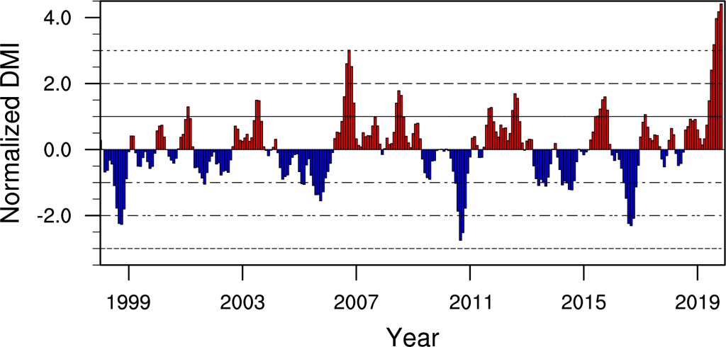
If we're to talk about climate change then we have to actually examine it in causal relation to the fires, how the climate has affected weather patterns and how the weather has made extremely favorable conditions for the present fires. The comparison has to be mediated by certain qualities for point of comparison and value of their qualities in relation to an understanding of the global climate trends and the particulars of the ongoing fire which was predicted as a result of the Indian Dipole which has been one of it's strongest positive's as of late.
Also add the Statosospheric warming over Antarica.
https://publicnewsupdate.com/news/climate-change-is-making-australias-weird-weather-even-weirder/Many of the biggest fires in Australia have occurred where forecasters anticipated the risk was the highest. One of the main signals of the extreme heat and drought of 2019 emerged when the Indian Ocean Dipole, the temperature gradient between the eastern and western parts of the Indian Ocean, reached record strength. This pushed moisture away from Australia in the spring. There was also a bout of sudden stratospheric warming over Antarctica, also reaching record levels. This heated air over Antarctica was channeled toward Australia’s surface with the help of the Southern Annular Mode, a westerly band of wind circling Antarctica.
The hot, dry conditions in 2019 also came after Australia’s third winter in a row with very low precipitation. That means there was precious little water on the ground to soak up heat, allowing the landmass to get hotter and hotter.
It turned out that the middle of the continent absorbed so much heat that it overwhelmed the moderating influence of the oceans on the coasts. “What we saw recently was essentially the hot and dry interior impinging on the coasts because winds from the pressure systems were bringing that sort of hot, dry … central Australian air or Western Queensland air onto those coastal areas, and that’s part of the reason why we had such extreme fires,” Howden said.
Earlier in the article
Why Australia’s weather is so erratic
Several factors contribute to Australia’s notoriously shifty climate. Australia’s landmass is large enough to include climate regions from the tropics in the north to deserts in the middle to temperate regions in the south.
The continent is also situated between the Antarctic, Indian, and Pacific oceans. Along Australia’s coasts, these oceans act like buffers and help moderate the climate in cities like Sydney. But Australia is a continent, which means it experiences continentality, a phenomenon where inland areas far from water experience a wider temperature range than the coasts.
That’s not to say that oceans don’t influence the middle of Australia. The surrounding bodies of water undergo periodic changes in water and atmospheric circulation patterns: El Niño, the Indian Ocean Dipole, the Southern Annular Mode, and so on.
Depending on the phase of their cycles, these patterns can bring torrential rains, searing heat, high winds, or cool breezes. When several patterns align, they can easily push weather toward extremes, particularly in the middle of the continent. That’s a big reason Australia has the most variable rainfall of any continent, explained Howden.
“When we get a wet year in Australia, it’s actually detectable in terms of the sea level rise across the globe because there can be so much water sitting on the continent that you can actually lower the sea level a little bit,” Howden said.
Even in Australia’s driest year on record, cities like Townsville in Queensland saw massive rainfall and flooding.
Another factor in Australia’s weird weather is that it doesn’t have a large inland system of lakes and rivers. Some large lakes can form during periods of torrential rain, but those lakes aren’t very deep, which means they don’t store much heat and can evaporate quickly. That reduces their capacity to cushion surrounding regions against temperature extremes.
Australia also doesn’t have a large, snow-capped mountain range like other continental landmasses. Melting mountain snow can act as a reservoir for water throughout the year and keep rivers and lakes topped up. For Australia, this makes inland areas more dependent on rainfall and more vulnerable to drying out in droughts than areas that do have white peaks to supply water.
Together, these elements leave many parts of Australia ping-ponging between deluges and droughts as well as heat and cooler air.
The influence of these winds, temperatures and such on the variability of weather conditions in Australia and the risk of fires is of interest.
[ulr=https://www.ncbi.nlm.nih.gov/pmc/articles/PMC6752822/]Understanding the variability of Australian fire weather between 1973 and 2017[/url]
In addition to this interannual variability, the climate of Australia is changing over longer time scales. The State of the Climate 2018 report for Australia [26] notes that the average surface temperatures have increased by just over 1.0° C since 1910, with about 70% of this change occurring since the 1970s. There has also been about a 10–20% decline in cool season rainfall across southern Australia since the 1970s, while many parts of northern Australia have seen wetter conditions. Coincident with these changes, an increasing trend in seasonal values of FFDI has been noted across much of southern Australia [3,4]. These changes are believed to be closely associated with the observed global increase in greenhouse gases, but the signal is potentially modulated by the Interdecadal Pacific Oscillation (IPO), an ENSO-like pattern of decadal (i.e. 10–40 year) SST variability that has been identified through statistical analysis of historical records [27] and linked to fire risk [15]. While the science of climate change continues to strengthen, Australian fire weather studies have less often investigated the link between observed increases in fire weather and climate change. However, a recent study based on gridded data across Australia found that changes in fire weather conditions in southern Australia are attributable, at least in part, to anthropogenic climate change, including in relation to increasing temperatures [3].
...
This discussion here strongly points to anthropogenic climate change as one of the major causes of long-term variability in fire weather in Australia, particularly in the southern portions of the continent, consistent with conclusions based on gridded data throughout Australia [3] complementary to the approach of this study based on station data. However, this is not an attribution study, and the evidence presented here remains circumstantial. A formal attribution study of FFDI in southeastern Australia presented by [75] did indicate that an anthropogenic climate signal was detectable in the FFDI record, while [76] are less clear about the link. As suggested here, the magnitude of the anthropogenic signal in [75] was smaller than the swings suggested by ENSO. We also note that anthropogenic climate change may also impact fire weather indirectly, for example by modifying the underlying climate drivers. For example, a future increase in the frequency of El Niño events and positive IOD events [46,47] as well as increasing positive polarity of the SAM index [77] have all been suggested under global warming scenarios. Additionally, a recent study by [78] found that the trend and variability of Southern Hemisphere climate modes are (amongst others) being driven by climate change. The dynamics of global warming and its interactions with modes of interannual and decadal variability and its effect on fire weather in Australia remain uncertain.
So the work that needs to be done really is to contextualize the recent weather across Australia in relation to changes in the overall weather and how it relates to ENSO, IOP and SAM which are significant influences upon wet and dry conditions in Australia and hence the risk of fire.
https://www.ethicalpolitics.org/ablunden/pdfs/For%20Ethical%20Politics.pdf#page90
-For Ethical Politics

")


 - By Unthinking Majority
 - By ingliz
 - By Puffer Fish
 - By wat0n